For Kenya, one of the most immediate areas of potential benefit is agriculture.
The Kenya Space Agency has already been working with stakeholders to expand the use of Earth observation data in the sector. Its Crop Measurement and Evaluation initiative, launched in February 2026, uses satellite imagery and artificial intelligence to generate agricultural information, including crop maps, crop growth monitoring and yield estimates.
The initiative involves the Ministry of Agriculture and Livestock Development, the Kenya Agricultural and Livestock Research Organisation, Microsoft AI for Good Lab, NASA Harvest and other partners.
The agency says the information can help identify crop damage, improve yield forecasting and support early warning systems.
Such applications matter in a country where farmers and policymakers need timely information to make decisions about planting, production and food security.
Better crop information could help government agencies assess production prospects, identify areas facing crop stress and improve the targeting of agricultural support.
Farmers could also benefit if useful information reaches them in a form they can understand and apply when making decisions about their farms.
However, the potential benefits of the proposed Chinese partnerships will depend on how the technology is integrated into existing agricultural programmes and whether the resulting information is accessible to the people who need it.
Building Kenya’s ability to use space data
The discussions in China also covered the development of Kenya’s technical capabilities.
At MinoSpace, a company specialising in satellite design and manufacturing, the Kenyan delegation discussed potential cooperation in capacity building, access to satellite data and the development of capabilities across the space industry.
The delegation also visited Emposat, which provides satellite tracking and control services, ground stations and space-ground communication systems.
These systems are important because satellites require communication infrastructure to transmit information and receive operational instructions. Access to data is also only one part of the process. Countries need people and systems capable of processing the information and applying it to local needs.
For Kenya, developing this expertise could create opportunities for scientists, engineers, researchers and technology specialists.
It could also strengthen the ability of Kenyan institutions to work with satellite information rather than relying entirely on external expertise to interpret it.
The Kenya Space Agency has a mandate to develop national space capabilities and promote the use of space technology for socioeconomic development.
Its engagement with Chinese companies therefore presents an opportunity to explore how international cooperation could support that mandate.
But the value of such partnerships will depend on the terms agreed, the skills transferred and the extent to which Kenyan institutions and professionals participate in the work.
Training and research could expand opportunities for young people
The Kenyan delegation also visited Beihang University, a Chinese institution specialising in aeronautics and astronautics.
Discussions with the university's leadership focused on aerospace research, human capital development and closer cooperation with the Kenya Space Agency.
University officials told the delegation that nine Kenyan students were enrolled in undergraduate and postgraduate programmes, including aerospace engineering.
Kipkosgey called for stronger cooperation between the agency and the university through aerospace studies centres.
He also acknowledged scholarships awarded to Kenyan students studying in China.
The engagement provides a basis for exploring further academic and research links, although no new scholarship package or training programme was confirmed in the reports of the visit.
Expanded cooperation could give Kenyan students and researchers opportunities to gain specialist knowledge in satellite engineering, space science, communications and data analysis.
The benefits would be greater if training opportunities were linked to practical projects in Kenya, allowing graduates to apply their skills within local research institutions, universities, government agencies and private companies.
Developing local expertise would also help Kenya retain more of the economic and scientific value generated by investments in space technology.
Potential role in climate monitoring and disaster preparedness
Satellite data could also help Kenya monitor environmental changes and prepare for some natural hazards.
Earth observation information can be used to track changes in vegetation, monitor water bodies and assess the effects of floods or drought. Satellite-derived information can complement ground observations and other data used by government agencies.
This has potential value for communities affected by increasingly difficult weather conditions, as well as authorities responsible for water resources, land management and emergency planning.
Kenya has already taken steps to improve the coordination and use of such information.
In March 2026, the Kenya Space Agency launched the Kenya Earth Observation Data Sharing Framework.
Developed with the British High Commission in Kenya, the Research Institute for Innovation and Sustainability and VIFFA Consult, the framework seeks to improve the sharing and use of satellite-derived information among government agencies, researchers, businesses and other stakeholders.
The agency has identified agriculture, natural resource management and urban planning among the areas that could benefit from better use of space data.
The proposed Chinese partnerships could complement these efforts if they improve access to relevant data, strengthen analytical skills or support the development of infrastructure.
However, the availability of satellite images alone will not solve problems such as food insecurity or inadequate disaster response.
Public institutions must be able to interpret the information, incorporate it into planning and communicate useful findings to affected communities.
Why ground infrastructure and data analysis matter
The discussions in China covered more than the manufacture of satellites.
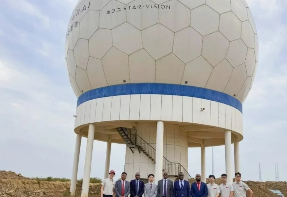
The Kenyan delegation visited STAR.VISION's ground station, data centre and satellite assembly, integration and testing facilities. It also toured facilities associated with rocket manufacturing and spaceport infrastructure.
The agency's engagement with STAR.VISION has included cooperation on artificial intelligence-powered processing and analysis of satellite-derived data.
This is significant because the benefits of space technology depend on an entire chain of capabilities, from collecting information to transmitting, processing and applying it.
For example, a satellite image may reveal changes in vegetation, but agricultural officers and researchers still need to interpret those changes and determine what they mean for crop production. Similarly, information about flooding becomes more useful when emergency planners can use it to identify affected areas and guide responses.
Stronger capabilities in data processing and communications could therefore help Kenyan institutions turn satellite observations into information that supports practical decisions.
The extent of the benefit will depend on access arrangements, the cost of the technology, the reliability of the systems and the capacity of local institutions to use them.
The challenge of turning discussions into results
The engagements come as Kenya seeks to strengthen its technological capabilities through international partnerships.
China has a substantial aerospace industry, with companies involved in satellite manufacturing, launch systems and ground communications.
Working with Chinese institutions could offer Kenya access to equipment, technical knowledge and research opportunities.
But the immediate outcome of the recent visit remains exploratory.
The Kenya Space Agency has not announced, in the reports reviewed, a new satellite purchase, a funded infrastructure project or a signed agreement arising from the discussions with MinoSpace and Emposat.
The next step is to establish which proposals can be implemented, what they will cost and how the country will measure their benefits.
For Kenya, the most useful arrangements would be those that go beyond access to imported technology.
They would also build local skills, support research, strengthen public institutions and make relevant satellite information available to users across the country.
The government would also need to consider the management, security and accessibility of space-derived data, particularly where it informs public planning and essential services.
Kenya's existing Earth Observation Data Sharing Framework provides a foundation for coordinating how such information is shared and used.
Measuring success by the benefits to citizens
The value of Kenya's space cooperation with China will ultimately be measured by what the country can do with the technology and knowledge it acquires.
For farmers, that could mean better information on crop conditions and production prospects.
For public agencies, it could mean stronger evidence for planning and managing natural resources.
For students and researchers, it could mean more opportunities to develop specialist skills and contribute to Kenya's growing space sector.
Those outcomes are possible, but they are not guaranteed by diplomatic visits or discussions with technology companies.
They will require clear agreements, investment decisions, technical training and effective cooperation between government agencies, universities and the private sector.
Kenya has begun developing the systems needed to use satellite information for national development.
Its emerging discussions with Chinese companies and universities offer another avenue to strengthen that work.
The test will be whether the partnerships produce capabilities that Kenyan institutions can sustain and information that improves decisions affecting people's livelihoods.